

Course to Steer
We saw in the top tip on calculating our Estimated Position (EP), that the tide has an effect on or actual course over the ground. In this section we will look at how we correct for tide and wind in calculating a Course to Steer (CTS) to get us from our present position to our next desired waypoint.
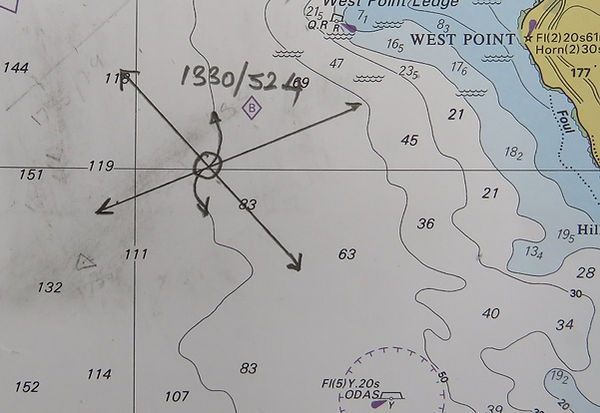
To do this, let us consider a navigation problem using the RYA training Chart 3. At 1330UT, a skipper fixes her position using bearings from a lighthouse and an oil platform. To confirm this fix she uses the depth (corrected for tidal height) of 100m. Her log read 52.4. The fix on his chart looks something like this:
She decides that he wants to head for the anchorage in Stubbington Bay, so plots that on the chart and measures the Track:

The next step is to find out what the tide is doing for his passage time. Tidal diamond B is quite close (just off the chart excerpt above); Tidal Diamonds in "RYAland" are referenced to Port Victoria, so first stop is the Victoria tide table. It is Monday 7th January. The entry is shown below:


In order to get the Tide Set and Rate we need the 'tidal hour' - i.e. how close to HW is our passage period? To find out, the easiest way is to construct a tidal ladder. The HW hour is 30mins either side of HW, then we extrapolate outwards before or, if necessary after, HW :

(In reality, one would probably round off the time to 1700)
We see from the above ladder then that the period we are interested in, departing at 1330 is 3 hours before high water. We now go to the top of the training chart to find the Tidal Diamond data:

This gives a set of 154*T , a springs rate of 3.9kts and a Neaps rate of 2.0kts. To be completely accurate we should use the Computation of Rates graph to find the rate at todays tidal range... which is between the two at 3.2m.


Now, we lay off the tidal vector of 154/2.6 (i.e one hours' worth of tide) on the chart from our start point:

We then open our dividers/compasses to a distance equal to one hour of boatspeed (in this case boatspeed is 5 kts, so we need 5nm). We then arc off 5nm from the end of the Tidal vector to cross the track line:


This gives us the complete 'Triangle of Velocities'. One arrow = Course to Steer/Boatspeed, Two Arrows = Track (or Course over Ground(COG))/Speed Over Ground (SOG), and Three arrows = Tidal Vector:

We can now measure CTS and SOG:


With a Speed over Ground of 6.5kts we can calculate our ETA:

We need to correct the True CTS of 087*T for Wind Effect (Leeway) and Variation and Deviation to give a compass course to the helmsman. I will cover the details in another top tip but, essentially, in pictures:


Simple as that!......
"Steer zero eight zero compass, helmsman, Boatspeed five knots, we'll be at the anchorage around 1420!"